Showing posts with label Durango. Show all posts

Tuesday, September 4, 2012

Haflin Creek Trail-Durango


The Haflin Creek Trail is a 5 mile route that climbs from the Animas River Valley floor up to Missionary Ridge, north of Durango in southwest Colorado. The trailhead is about 7 miles north of Durango along Highway 550, then east 1 mile on Trimble Lane and south 1.2 miles on County Road 250 to a gravel turn toward a Forest Service Work Center. I didn't notice a sign for the trail along the road. The Dalton Ranch Golf Course is in this area.


The first segment of trail climbs steeply with back and forth switchbacks above the trailhead area. There are increasingly higher views above the Animas River and southwest views toward Animas Mountain and the Hidden Valley area. The trailhead elevation is 6600 feet and there is 1000 feet of climbing before the trail starts to level off.


There are also good views to the north. The Haflin Creek Trail features a rich variety of trees. Gambel Oaks, Pinon Pines, Utah and Rocky Mountain Junipers, and Ponderosa Pines are all in view along the climbing segment. Further on are Douglas Firs and Aspens.


As the trail turns east along the north shoulder of Haflin Creek, the effects of the 2002 Missionary Ridge Fire become apparent. The Missionary Ridge Fire burned for 39 days beginning in June 2002. The burned area was measured at 73,000 acres and extended from here east to Vallecito Reservoir.

Ten years later, there are Gambel Oaks returning, but the tall pines and firs are scorched reminders. Baldy Mountain at about 9700 feet is the high point ahead.


The route continues to climb, but more gradually. There are two dry creek crossings and Haflin Creek has only a trickle of water. In early September, some fall color is starting to appear.


Further up the trail, young Aspens are growing. I turned around after 2:15 hours and about 4 miles at about 8500 feet elevation. There is a trail junction with the Missionary Ridge Trail about 1 mile further and 1100 feet higher.


My return hike took 1:45 hours for a total hike of 4:00 hours for about 8 miles. It was an 82 F degree early September day and I carried 3 liters of water. I saw 14 other hikers and 6 dogs during my hike.


Tuesday, May 1, 2012

Dalla Mountain Park in Durango


The Dalla Mountain Park is a small trail system of about 4.7 miles on the northwest side of Durango in southwest Colorado. Turn west at 25th Street from Highway 550 and find a small parking area on the right after about 1 mile.


This area is along Junction Creek, the same area where the Colorado Trail begins further along the road. The Falls Creek Archaeological area is also in this area. Dalla Mountain Park trails also connect to the trails on Animas Mountain. Like other Durango area trail systems, there are good map signs at each major trail junction showing where you are and where the alternate routes lead. The maps also show the distance for each segment.

At the trailhead area there are three choices. I stayed to the left on the segment that looks like an old road. The trail climbs gradually through tall Ponderosa Pines and Gambel Oaks.  In late April, the oaks were just starting to leaf out. I tried to mostly follow the outer segments to make a large loop.


Most of the trail segments in Dalla Mountain Park have descriptive names, starting with Jacobs Cliffs. Some of the middle segments are labeled Bouldering. It becomes obvious quickly that there are many large boulders scattered all around the trail system. Many of the boulders offer nearly vertical surfaces up to about 20 feet high.

At the northern end of the system there are some views west toward the LaPlata Mountains. One of the trail segments at this end leads downhill to another trailhead. The trail continues climbing before making a loop in the segment named Sailing Hawks. There were a couple of Turkey Vultures sailing in this area during my hike. Among the Ponderosa Pines I saw one tall spruce tree in this upper area.


Descending on the north edge of the Bouldering segment the trail passes along the cliffs of Animas Mountain and one of the largest boulders. Along the trail I saw about 10 other hikers and one person trying some climbing.

The only wildflower I saw was this Serviceberry bush in the Rose Family. The Utah Serviceberry is common in the Pinon Juniper forests but I think this is the species that grows in more alpine habitats. My hike at Dalla Mountain Park took 1:30 hours for about 2.9 miles on a 65 F degree late April day.


Friday, December 30, 2011

Discovery Museum on the Animas River Trail

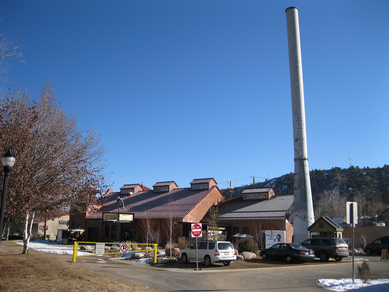
One of the historic sites along the Animas River Trail, in Durango, Colorado, is the Durango Power Plant. In 2011, the historic plant has been restored and re-opened as the Durango Discovery Museum.

I started my hike on the Animas River Trail at the Santa Rita Park. Following the trail north, it is about 2 miles to the Discovery Museum. The Santa Rita Park is about 1 mile south of the junction of Highways 160 and 550.
In 2011, there is a $9.50 charge for adults. Much of the interior space is devoted to hands on activity for children, with an emphasis on electricity. The displays are still in development but there was a lot of activity on the day I visited.

I thought the most interesting area for adult visitors was the old boiler room area and the adjacent turbine and generator. This large room also has a screen for video displays and some chairs for viewers. The manufacturing information attached to the boilers says Heine Safety Tube Boiler, and Risdon Iron Works Builders, SF CAL. 1908, and also Utah Copper Company 1906. There are also antique valves, pumps, and gauges in the boiler room.

One of the boiler doors is open for a view of the boiling tubes. Originally the power plant used coal, and converted to gas in the 1940s. In the mid 1970s the plant was shut down and sat idle until 2002 when the renovation activity began. The exterior was completed in 2006.

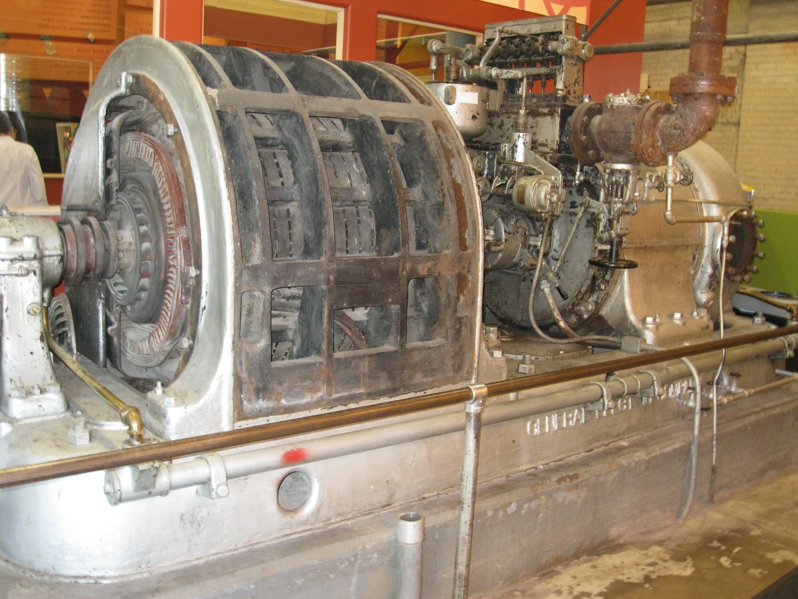
 Sitting just outside of the boiler room is one of the turbine engines and an attached generator. The manufacturing inscription says General Electric Company. The Durango Power Plant was one of the first on the western slope of Colorado to use AC power.


The Durango Power Plant used California Mission style architecture with two twin towers on the north end. The east side tower has an unusual way for visitors to climb up to the top of the tower for the roof top views both outside and inside. There is a circular series of steps, but the climber has to twist from side to side to make the climb. This unusual climb can start at the floor level or about halfway up after climbing normal stairs.

From Santa Rita Park it took me about 0:45 minutes to arrive at the Discovery Museum. My total hike with the museum visit and some searching for the Durango Pumas on Parade took about 3:30 hours on a 40 F degree late December day.


Friday, August 19, 2011

Big Canyon Trail-Durango

The Big Canyon Trail is part of an extensive network of trails in the Telegraph Trail System on the south side of Durango in southwest Colorado.

The Big Canyon Trailhead is somewhat hidden behind an auto dealer on the northeast corner of Highway 550/160 and Dominguez Drive, across the highway from the Walmart. There is a marked parking area about 100 yards west of the trailhead. The Carbon Junction Trailhead and Sale Barn Trailhead are nearby alternate entry points into this system.

Many of the Durango City trails have good trail map signs at trail junctions that make it clear where you are and where the alternate trail choices lead. These trails are open to hikers, horses, and mountain bikes with most users probably riding bikes. At the Big Canyon Trailhead there is an interpretive sign explaining the importance of this wild area to Elk and Deer as winter range, depending on how severe the winter is.

At the trailhead there are two trails visible, the main trail leading into the canyon bottom and a thin trail descending from the mesa top. The main trail leads along a dry drainage through Gambel Oak, Pinon Pine, Utah Juniper and the lighter blue green Rocky Mountain Red Junipers. Bike riders describe this segment as swooping.

There are several large rock outcrops visible along the canyon bottom. After about 1.6 miles there is a trail junction with the South Rim Trail and a good map sign. I made a left turn onto the South Rim Trail.

This segment of the South Rim Trail returns toward the Big Canyon Trailhead along the mesa top, and overlooks the canyon bottom where I had just hiked. When it reaches the trailhead overlook, there is the thin side trail that was visible at the trailhead. I followed the steep side trail back to the trailhead to complete a 3.2 mile loop.

My short loop hike took 1:15 hours on an 85 F degree mid August day. I didn’t see anyone else while hiking but one mountain bike swooped past me just as I finished.


Thursday, August 18, 2011

Animas River Trail (south)-Durango

The Animas River Trail runs for about 6.75 miles connecting many riverside park and recreation areas in the Durango area in southwest Colorado. The trail continues to lengthen over the years with some of the newest extensions being on the south end.

Visitors to Durango can easily access the Animas River Trail near the midpoint at Santa Rita Park, about 0.5 miles south of the junction of Highways 550 and 160. In the summer, rafts and kayaks are often visible in this stretch of river near the Whitewater Park. From the park, there is a nearly equal distance of trail leading north or south.

The segment leading south to the Durango Mall is more in wooded riparian stream-side habitat than most of the trail segments. There is a short side trail at one point leading to some Flintstones style rock slab picnic tables. There is an interpretive sign describing the site of the Weidman Sawmill, which operated during the mining era and continued until the 1970s.

There are good river views from the new trail bridge that is a short distance south of the Durango Mall. The interpretive sign on the bridge describes the Gold Medal trout fishing on the Animas River.


The six stages of the life of a trout are briefly described. The life stage terms used include redds, alevins, fry, and parr before becoming mature. Fishermen are urged to give the hard working trout a break and avoid casting over the spawning areas, March for the Rainbow Trout and October for the Brown Trout.

Toward the south end of the trail, there are views across the stream toward the rock formation known as the Purple Cliffs. There is a road bridge with a pedestrian lane across the river leading to the small Dallabetta Park that is the current south end of the Animas River Trail.

It took me about 1:30 hours, one way, to walk the south trail segments from Santa Rita Park, about 3.5 miles. In August 2011, there is some trail reconstruction behind the Durango Mall that causes a detour.

544544_$20 off any hotel booking of $350 or more with code TLSALE20

Friday, July 8, 2011

Lower Hermosa Creek Trail

The Hermosa Creek Trail System in the San Juan National Forest has 14 designated trails that offer multi use opportunities for hikers, bikers, horses, and motorized. The South Hermosa Trail Head is about 10 miles north of Durango in southwest Colorado. Turn west from Highway 550 at County Road 201 just north of the bridge across Hermosa Creek and just south of a railroad crossing.

It is a few miles of paved county road and gravel Forest Road 576 to the well developed trail head area. There are campsites associated with the trail head and there are facilities for horse trailer parking. Hikers starting here can follow the Hermosa Creek Trail or the Jones Creek Trail.
 
I followed the Hermosa Creek Trail which follows high along the shoulder of Hermosa Creek. The forest at the start is Ponderosa Pines and Gambel Oaks with Spruce and Fir visible along the creek. The Hermosa Creek Trail doesn’t get any ATV use as it is too narrow. Mountain bikes and horses pass along here with hikers.
An interpretive sign at the trail head says that these are old growth Ponderosa Pines and there are some particularly large examples along the trail. I didn’t see any large wildlife but elk and black bears live in this area along with elusive bobcats and coyotes.
 
After a couple of miles there are some views across the canyon toward some of the peaks to the west. Aspen trees also start to appear. There are several small creeks that cross the trail.

 After about 3.7 miles there is a trail junction with the Dutch Creek Trail. The trail junction is clear but I didn’t see any trail signs. I stayed left on the Hermosa Creek Trail that descended about 500 feet of elevation in about 1 mile to a small bridge and a campsite area. It took me about 2:05 hours to arrive at the bridge and I turned around there.

My return hike took 2:15 hours for a total hike of 4:30 hours for about 9 miles. On the return there was a 15 minute sprinkle of summer rain. I carried and drank 3 liters of water on an 80 F degree day. During my hike I saw 4 bikers and 2 other hikers. There was a crew with 4 horses doing some spraying of noxious weeds.


528614_Russell Outdoor Logo 125x125 18407_$5 Shipping on Orders of $99 or More! 544544_$20 off any hotel booking of $350 or more with code TLSALE20

Tuesday, June 14, 2011

Animas Mountain Trail-Durango

The Animas Mountain Trail is one of the Durango, Colorado in town trails. The main loop is about 6.2 miles with a starting elevation of 6600 feet and a high point at about 8100 feet. This is a good trail system during the early summer when the higher mountain trails still have snow.

I used the West 4th Street trailhead that is west from Highway 550 at 32nd street, then north on narrow 4th Street to a rough gravel parking area. I didn’t see any street signs pointing out the trailhead. From the trailhead, the trail is a rough rocky road that climbs steeply at first.
 
The lower elevation south section of the trail system has several confusing options, but there are map signs at each junction. Even with the signs, it seemed like there were some unofficial trail options that can cause confusion. To the west of the Animas Mountain Trail System there is another trail system called the Dalla Mountain Park that connects. There is access to the Dalla system along Junction Creek Road.
 
The east side of the ascending loop has the best views. The early segment has views mostly south toward the town of Durango. In mid June the Animas River is running full.

The forest along the east side is dominated by Gambel Oaks with a mix of Pinon Pines and Utah Junipers, Ponderosa Pines, and a few Rocky Mountain Red Junipers. Toward the north end of the area there are some spruce trees. After about 1.5 hours and about 3 miles there is a small bench. From the bench there are views toward Missionary Ridge and north up the valley toward the nearby mountains. Below, the cut off meanders of the Animas River are visible.
 
The north high point of the Animas Mountain loop overlooks the Falls Creek Archaeological Area and the hidden valley. The Animas Overlook Interpretive Trail overlooks this same area from the west. There are also some views toward the LaPlata Mountains to the west. It took me about 2:00 hours to arrive at this overlook.
 
The return west side of the loop passes through mostly Ponderosa Pines without any more views. My total hike for about 6.2 miles took 3:15 hours on a 70 F degree mid June day. I saw about 5 other hikers and 3 mountain bikers while I was hiking. I carried and drank 2 liters of water.


532497_120 x 90 Starting Salary $42k. Group 1

Sunday, May 8, 2011

Falls Creek Archeological Area

The Falls Creek Archaeological Area is a 1500 acre section of the San Juan National Forest in a hidden valley on the northwest side of Durango in southwest Colorado. The trail head is in the Junction Creek area, reached by a west turn at 25th Street off of Highway 550. After the road name changes to Junction St, there is a north turn on County Road 205. At the north turn, there is a sign pointing out Falls Creek.

This 1500 acre area of the forest preserves archaeological sites from the Ancestral Pueblo Basketmaker period of 1500 to 2500 years ago. The area is divided in half by County Road 205 with the western half closed to all activity including hiking. There is a network of trails open in the eastern half of the area. I started my hike at the interpretive sign, but there are other pullover places along road 205 where hiking or mountain biking could start.
The valley floor is very flat and grassy with impressive cliffs on both sides near the trailhead. After a short distance, there is an option to hike on the east shoulder above the valley floor. At the top of the east shoulder, there are some views into the main Animas Valley area that is north of Durango.
 
The most obvious feature of the closed area is a large alcove in the cliffs above the grassy fields. A sign along the road says there is the Basketmaker Trail going up, but it is only used during special tours. Brief information on the Forest Service web site says there are two rock shelters, but only one is obvious.

Many artifacts from the shelters were found during excavation, but it isn’t mentioned where these artifacts are now. It is mentioned that the rock shelters have pictographs on the back walls.
 
In the north segment of the trail, the route descends steeply from the shoulder down to Falls Creek. The forest along the early segment of trail is mostly Pinon Pines and Junipers with Gambel Oaks. There are a couple of small bridges to cross the creek. In the creek area, there are more Ponderosa Pines and I saw one spruce. I continued a short distance further north into Ponderosa Pine forest and turned around after 1:00 hour of hiking.
The north part of the valley floor area includes a wetlands area. The interpretive sign at the trail head mentions that the Basketmakers grew corn and squash in addition to hunting deer, rabbits, turkeys, and porcupine, and gathering.

While hiking, near the wetlands, I could hear the continuous croaking of frogs, but didn’t see any ducks. There would have been Pinon nuts and acorns to find here. Native grasses and Yucca fibers were used to manufacture baskets, rope, sandals and bags.
 
There is some additional information on the Falls Creek area at the Animas Historical Museum, located nearby at 31st Street and West 2nd Avenue. The Museum is itself an historical site, the old Animas City School built in 1904-05. The school served until 1967. Restoration began in 1978 and is ongoing.
 
The Museum information mentions that the shelters were discovered in 1937. In addition to the two rock shelters, there is a talus slope village site. From the hiking area, one of the shelters is clear, but the second shelter and the talus slope locations are vague.

The sites were excavated by Dr. Earl Morris in 1940. Dr. Morris is also known for work around Mesa Verde and the Ute Mountain Park area. One of the hikes offered at Ute Mountain visits the Morris 3 site.

The people here were identified as from the Basketmaker II era and evidence of house construction was uncovered. The house description sounds like the interpreted early pit houses that are on display on the Mesa Top Tour at Mesa Verde.
 
There are a few artifacts on display at the museum. The people manufactured tools from the local stone and bone resources that are mostly still visible. There were also materials, like obsidian, lignite and shells found that are not locally available and could only have been traded into the area.

These imported materials were often used in making beads and pendants for personal use. These personal artifacts were considered important as giving clues to the spiritual and emotional life of the residents.

My hike from the introductory sign to beyond Falls Creek lasted for 2:00 hours on a 70 F degree early May day. I saw one other hiker and several mountain bikers during my hike.