Showing posts with label Dolores River Lower. Show all posts

Sunday, October 7, 2012

Dolores River at Salter Canyon-Lone Dome


Salter Canyon is a north side canyon of the Dolores River in the Lone Dome Recreation Area in the San Juan National Forest in southwest Colorado. The Lone Dome Recreation Area is located 6 miles east of Pleasant View and includes the first 12 miles of Dolores River below the McPhee Dam.


I parked at the Ferris Canyon Campground which is open in the off season and is about 7 miles east along the Lone Dome Forest Road. Salter Canyon is about 0.4 miles further east. From the campground you can hike along the gravel Forest Road or along the banks of the Dolores River. There is a fence along the road with an easy gate near the mouth of Salter Canyon.


There is a wide creek bed with a bridge at the mouth of Salter Canyon. On the west side there is an unmarked trail that follows up the canyon. It looks like this trail was once a road but is now abandoned. The lower canyon has Ponderosa Pines and with thickets of Gambel Oak. There are also Rocky Mountain Junipers and Narrowleaf Cottonwoods along the creek.


The west side of the canyon has steep sandstone walls. I scanned the canyon walls for signs of ruins sites but didn't notice anything. The thickets of oak made it difficult to approach the canyon walls.


The trail was easy to follow for about 0:30 minutes or about 1 mile and then the forest became very thick and the trail overgrown. I saw one very large Ponderosa Pine near the upper end of my hike.


My hike in Salter Canyon was for about 1:00 hour with some additional time looking along the Dolores River. My total hike was for about 2:30 hours on a 70 F degree early October day. Other points of interest a little further east in this area include the old cabins that were the Lone Dome Ranger Station in 1912. There are also some old ranching structures in the same area.


Thursday, August 16, 2012

Dolores Canyon Overlook at Dove Creek


There is a marked turnoff for the Dolores Canyon Overlook on the south side of Dove Creek, along Highway 491 in southwest Colorado. From the turnoff it is 10.4 miles to the Overlook. There are BLM signs marking the way.


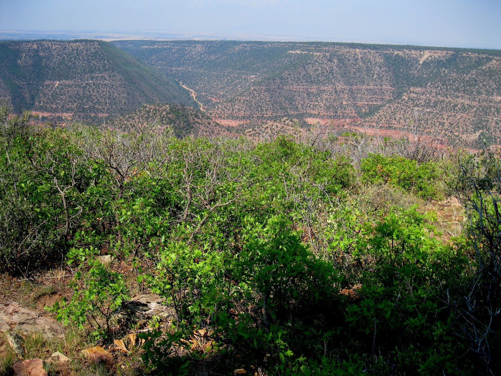
The Overlook is on a point of land high above an entrenched meander of the Dolores River downstream from the Bradfield Bridge area of the Lower Dolores River. There is a short trail out to a view point with picnic tables along the way. The Dolores River is visible on both the east and west sides of the view area. The elevation at the Overlook is about 8000 feet and the river is at about 6200 feet.


At the end of the trail there is a constructed view point. Directly north, the point of land visible is known as Mountain Sheep Point. Below, the Dolores River makes a sharp turn from north to south.


Flowing south for a short distance, it makes another sharp turn back to the north around Mountain Sheep Point. Below the south tip of Mountain Sheep Point, the access road from Dove Creek arrives at the canyon bottom where rafters can access the river and hikers and others can follow a rough road downstream for at least 12 miles.


There isn't an official trail along the canyon rims, but the terrain is open enough to allow some hiking. There may be the remains of an old road along the rim that cows now use. I walked for about 0:30 minutes south along the west rim. The road that descends into the Dolores Canyon to the river access
is visible across the canyon.


After 0:30 minutes south I turned east and it took 0:25 minutes to arrive at the east rim. The road is much closer to the east rim than the west rim. The terrain in between is Gambel Oak and Ponderosa Pines and was mostly easy walking. The only obstacle was the thicker patches of the oak. There is a fence to cross near the road. From the east rim I took 0:35 minutes to arrive back at the parking area. 


I thought these views and the terrain were similar to the Black Canyon of the Gunnison National Park near Montrose, Colorado. But despite the spectacular views, the Dolores Canyon Overlook is only an obscure site that is lightly visited.

On the road near the overlook I saw a Blue Grouse and I think I saw two coyotes sprinting across the road. There was a third animal about the same size as the coyotes but with a more lumbering gate. It wasn't large enough to be an adult bear, but may have been a young one. I just got a brief glimpse.  I spent 2:00 hours for about 3 miles of walking on my visit on a 75 F degree mid August day.


Tuesday, July 24, 2012

Dolores River at Slick Rock


Slick Rock is one of five boat launch sites along the lower Dolores River in southwest Colorado. It is 28 river miles below Dove Creek and 14 river miles above Big Gypsum Valley. On the road, it is 22 miles east of Dove Creek on Highway 141.


The Slick Rock site is the only one of the five launch sites that is on private property and there is a fee to park there. About 1 mile further east on Highway 141 there is a pull over point with an old road that descends to the river bank and provides about 1.3 miles of trail along the Dolores River. The area with the trail is on the BLM managed land.

This trail is slightly upstream of the boat launch point and travels further upstream. The Dolores River flows alongside Highway 141 from the trail down to the launch. The flow of the Lower Dolores River is controlled at the McPhee Dam about 60 river miles upstream.


During the time period that I hiked the water release had been steady at 70 cfs. During late July local showers could cause temporary increases in flow. I noticed that the flow 50 miles downstream at Bedrock was steady at about 52 cfs during my hike but shot up to 170 cfs later in the afternoon, before gradually decreasing.
The trail descends to cross a dry creek bed and then passes through a gate. A sign on the gate reminds visitors not to disturb archaeological resources. The Dolores River is very silty here after leaving the Dove Creek area still very clear. There appears to be a lot of willows along the bank but not much other riparian habitat. I checked the large boulders along the way for petroglyphs and kept an eye out for ruins sites but I didn't notice anything.


The east side of the Dolores River next to the trail is steep and rocky while the opposite side is grassy with mild slopes. There appears to be a trail on the other side of the river that continues further upstream. After about 1.3 miles and 0:35 minutes of hiking the trail fizzles out. My total hike took 1:10 hours for 2.6 miles on an 86 F degree late July day.


Saturday, June 30, 2012

Dolores River Canyon at Dove Creek


The Dolores River Canyon can be accessed near Dove Creek, Colorado. There is a marked turn off from Highway 491 on the south end of town. After about 1 mile there is a north turn near a radio facility that leads down into the very deep canyon.


Just past a pump station, there is raft launching site with a pit toilet and a couple of picnic tables. The Dolores River canyon here is BLM managed land on the west edge of the San Juan National Forest.


From the raft launch site, a rough dirt road leads north for about 12 miles, with a rougher trail continuing toward the Slick Rock launch site. The Dove Creek access is 19 river miles below the Bradfield Bridge access. All of these access points are on the lower Dolores River below McPhee Reservoir. I began my hike at the raft launch site. Most vehicles can drive the first 0.5 miles to the Box Elder Campground and high clearance vehicles can continue.


The habitat along the Dolores Canyon bottom includes small groves of Ponderosa Pines and Gambel Oaks. Close to the river there are willows and Box Elders. I didn’t notice many Cottonwoods. The canyon sides had Pinon Pines and Junipers with some Douglas Firs in the high shady spots.


The geology appears to be the sandstone layers that are familiar in the Canyonlands and Arches area. The steep cliffs of the Wingate Sandstone support the Kayenta, Navajo, and Entrada Sandstones. The trail appears to be carved out of the softer Chinle layer and the sandstones rise higher as the trail proceeds north.


Along the trail there are frequent parallel side trails to river side campsites. After about 0:45 minutes I followed one of these side trails and had a Black Bear sighting. The bear had already turned and made a short jog away when I saw it from about a 100 feet distance. I had a good view for about 5 seconds and then it dashed away into the oak brush.

 Near where it had been was a large patch of these Sumac Berries. Along the trail I saw deer tracks but no deer. There were ATV tracks on the trail but I didn’t see hiker or mountain bike tracks.

There are a couple of boulder strewn riffles along the segment that I walked. The lower Dolores River flow is controlled at the McPhee Dam. On the day I hiked the flow was recorded from below the dam as 69 cfs. This is well below the historic average of about 220 cfs. The water in this area appeared to be clear flowing. When I've viewed the Dolores River downstream at Big Gypsum and Bedrock it appears to have much more silt.

The side canyons in this area are steep gaps in the rocks without any flowing creek water. It looks like this section of canyon could only be accessed at very limited locations.

I turned around after 2:10 hours and about 4.5 miles at one of the riverside campsites. My return hike took 1:50 hours for a total hike of 4:00 hours for about 9 miles.
It was 77 F degrees at my 9:40 AM start and a warm 88 F degrees at the 1:40 PM finish. I carried and drank 3 liters of water. I didn't see anyone else on the trail during my hike but there were several campers in the Box Elder Campground.


Saturday, January 7, 2012

Sage Hen Forest Road to McPhee Dam

The area on the west end of McPhee Reservoir on the Dolores River in southwest Colorado is known as the Sage Hen area. Running straight north for 4.3 miles from Sage Hen is the very rutted and rough Forest Road 500, leading to the McPhee Dolores River Dam site. This Forest Road has been closed to motorized vehicles since 2008.

The trail climbs through a sagebrush plain area with scattered Pinon Pines and Junipers and gives good views of the McPhee Reservoir with Mesa Verde becoming visible the higher you go. The LaPlata Mountains with Mt. Hesperus are also visible to the east. This area gets some use from mountain bikers and horse riders in addition to hikers. There is also fishing and boating access in the side roads close to the McPhee Reservoir.

Descending into Lone Dome Canyon through a side canyon, the Dolores River discharging from the dam flows west. The Dolores River State Wildlife area protects the river through this area. The forest on the north facing canyon wall has Ponderosa Pines and Douglas Firs.

A service road bridge allows easy crossing into the developed Mataska Recreation Area below the dam. The posted historical information discusses how cattlemen were the first to settle this area and at the end of summer the cattle were driven through this area to the rail line in Dolores for shipment to Denver and Kansas City.
 
Near the Mataska picnic ground there is a service road that goes to the top of the dam. Interpretive information in the picnic area reports that the dam was built in 1984, is 270 feet above the river bed, and the water covers 4,470 acres. Irrigation water from McPhee Reservoir is distributed by canals through the area and keeps it greener than it would otherwise be.

It took me about 2:00 hours to get from Sage Hen to the river and I spent about an hour in the river area and up on top of the dam. The total time for about 10 miles was 5:10 hours.

For a shorter hike, there are some artifacts of the human history of the Sage Hen area to see but they take some searching away from the main trail. There are two side trails leading toward the east from Forest Road 500. The first side trail is about 1.5 miles north. A short distance along the side trail there is an old corral.


South of the side trail, but not on the trail there is some sort of old camp with a number of old metal artifacts. This camp is near an old constructed pond.

The second side trail is about 2.3 miles north along the main trail. In the Sage Hen area some of the hilltops  appear to be archaeology sites. With some careful looking, there are some pottery shards visible. I thought the pottery shards I saw were thinner and mostly plain compared to the Black on White styles that are found in nearby canyons.

There are also a number of rubble piles that could be ruins sites. These rubble piles aren’t as distinct as the ones in the nearby Canyons of the Ancients. In a couple of places there are lines of large stones that seem to be turned on edge.


Sunday, May 22, 2011

Dolores River at Big Gypsum Valley

The Big Gypsum Valley is 34 miles east of Dove Creek, CO along Colorado Route 141. It is a BLM area that is north of Disappointment Valley and south of the Paradox Valley.

Thirteen miles northwest along the gravel road there is an access to the Dolores River that is used by rafters. The Gypsum Valley site is 55 river miles downstream from the Bradfield access and 36 serpentine miles upstream of Bedrock. Like the Paradox Valley, the Dolores River flows across the Gypsum Valley rather than down it, exiting one deep canyon and entering another.
 
The floor of the Gypsum Valley is grassland and supports some grazing activity. Along the valley edges there is some Pinon and Juniper forest. On the north side the Wingate, Kayenta, and Navajo sandstone layers are visible sitting on the Chinle layer. There is mining activity on the south side. The last three miles of gravel road becomes more of a dirt road after passing the mining sites.

I stopped at about 12.5 miles below a pinnacle formation that I think is called the Psycho Tower. This is a formation that rock climbers know and there is a trail leading up toward it. There are more climbing sites in the next 2 miles along the dirt road that are similar to the Indian Creek climbing area that is on the way to the Needles District of Canyonlands National Park. I started hiking down river along the road below the Psycho Tower.
 The road is level and smooth and provides easy walking. In the distance there are some views of the La Sal Mountains. From where I started it is 0.5 miles to the turnoff for the boat launch site. There are three covered picnic table camp sites at the launch site, but otherwise no facilities. The busy season for rafting on the Dolores River is May and June.

There wasn’t any activity here during my visit but the flow appears to be unusually low. I checked the web site info for flow at Bedrock for the time that I hiked and it was 200 cfs. This is too low for rafting and well below the median value of 1070 cfs for the day I visited. The discharge from the McPhee Reservoir has been 75 cfs for the previous week, after spending some time at 500 cfs. The historic average discharge for this time of year is about 1400 cfs.

The area where I started hiking had many cottonwood trees, but downstream from there Tamarisks had taken over. It looked like there has been work to remove the Tamarisks, but there is more work to do.
 
About 2 miles along the route, there is a bridge that crosses the river. After this bridge the Dolores swings around a bend to the left and enters the serpentine area of the Dolores River Canyon Wilderness Study Area. I turned around at the bridge, but the road continues into the Little Gypsum Valley and I could see side roads that visited the opposite side of the river across from the launch site.
 
 While hiking, I was checking the large boulders for petroglyphs. The only panel I found was very close to where I started my hike.

My total hike took 2:15 hours for about 4 miles. It was a 74 F degree late May day and I carried and drank 2 liters of water. I only saw 2 other people during my visit to this area.


528614_Russell Outdoor Logo 125x125 528614_Cool Camo Russell Outdoors

Thursday, April 21, 2011

Dolores River at Bradfield-Lone Dome Recreation Area

The Bradfield Recreation Site is known as the upstream launch point for rafting trips on the lower Dolores River in southwest Colorado. It is located about 5 miles east of Pleasant View, CO and about 12 miles downstream of the McPhee Dolores River Dam.


At the entry point to the Bradfield site, there are some old ranch structures remaining from the big valley ranch era and some fading interpretive signs explaining the ranching history of the area and some facts relating to rafting on the Dolores River. Near the interpretive signs, there is a dirt road leading into the Lone Dome State Wildlife Area that heads upstream for about 2 miles, providing some scenic hiking in this area.
 

This route is probably mostly used by trout fishermen. The road stays close to the canyon side, cutting through the Pinon Pine and Juniper forest. From the dirt road, there are places to turn off and access the river bottom area and the bank. The main forest road that leads to the area below McPhee Dam is visible across the sparkling stream.
 

Besides trout, the Dolores River here provides habitat for River Otters, Beavers, Deer, Elk, Peregrine Falcons, and Turkeys. Bald Eagles can be sighted in the winter months After the construction of the McPhee Dam ensured year round flow in 1988-91, the Colorado Division of Wildlife transplanted 20 Otters to this area.

In mid April 2011, there are signs of a recent forest fire. It looked like most of the large trees survived, the branches showing spring buds despite the scorching on the trunks. About two weeks after the blaze, the burned area is starting to recover with some green grass poking through.
 

At the end of the dirt road, there are some large rocks placed to form a pool, raising the level and diverting some of the flow into a water management project. Along this last segment, there is a small ditch, a flow measuring flume, and some small water control structures. My total hike here took 1:50 hours for about 4 miles. It was a 56 F degree mid April day.