Wednesday, August 20, 2008

Goble Trail

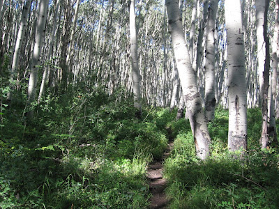
The Goble Trail is a 3.5 mile loop trail that climbs out of the West Fork of the Dolores River Valley up toward Nipple Mountain in the San Juan National Forest in southwest Colorado.
The trail head is about 10 miles north along paved West Fork forest road 535 and about 22 miles total north of the town of Dolores. There are a lot of trout fishing spots along the road here.

The lower part of the trail climbs along a small creek for about 15 minutes before reaching the loop. The forest along the creek is thick and mixed with Aspens, Engelmann Spruce, Douglas Fir, and Narrow Leaf Cottonwoods.

. This trail appears to get some use by horse riders, probably not very much from mountain bikers.
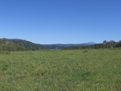
I took about 0:50 minutes of fairly steep climbing to get to the high point of the trail where the forest opened up into a meadow area and there were views of Nipple Mountain to the west topping out at 9763 feet. There is an old corral up on top along the trail and signs of cattle.


There are also views across the West Fork Valley to Stoner Mesa but no views to the mountains in the nearby Lizard Head Wilderness. The trail is a little confusing in this area as cow trails lead off in different directions. 

There are signs to help keep hikers on the trail but you have to keep an eye out for them and keep in mind that you want to loop back down to the east.


The south loop as I descended is a little more open and drier forest than the north side of the loop. There were ponderosa Pines in the higher area of this route. In mid August 2008 there were a few wildflowers along the trail but nothing spectacular. The lush mix of trees along the creek was more interesting than the flowers. It took about 1:40 hours to walk this loop trail.


Tuesday, August 12, 2008

Lower Stoner Mesa Trail

The Lower Stoner Mesa Trail starts at the Emerson Trail Head along the West Fork of the Dolores River in the San Juan National Forest in southwest Colorado.


The West Fork enters the Dolores River about 15 miles north of the town of Dolores. This trail is part of a 25 mile loop trail for mountain bikers that includes the paved road.

Dirt bikes and horses can also use this trail. The Emerson Trail Head area used to be a campground, but has been retired for camping for the last 10 years or so.

For hikers, the first part of the hike is along the bank of the West Fork River, then crossing a small bridge. Along the clear running stream are some tall Engelmann Spruce trees.

This is a good aerobic trail, climbing steeply with switchbacks through a mostly Aspen forest. The under story of vegetation is very thick and has a lot of waist high wildflowers. This route is like a narrow alley with chest high vegetation with shady Aspens overhead.


The views through the thick forest are across the narrow West Fork canyon with glimpses of the paved road below and a little up the canyon to the north. After the first 75 percent of the climb, the trail levels out for about 10 minutes. There are scattered Douglas Firs and Gambel Oaks high up.

The trail climbs more than 1200 feet and enters a high meadow area. A short distance across the meadow is a small constructed reservoir.

From the high meadow area there are views to Lone Cone Peak to the north and Mt. Hesperus back to the southeast. The trail continues on through a forested and meadow area.

It took me about 1:20 hours to get to the reservoir and I turned around there. My total hike was 2:30 hours.


Sunday, August 10, 2008

Dolores River at Cabin Canyon and the Bradfield Bridge

The Riverside Trail is a short paved no barriers trail in the Cabin Canyon Campground in the Lone Dome Recreation Area of the Dolores River. This is about eight miles below the McPhee Dam in the San Juan National Forest in southwest Colorado, and four miles above the Bradfield Bridge.


The Dolores River below the McPhee Dam is a good trout fishing area with very little development. The gravel road has numerous turnoffs with river access and there are two campgrounds. The Cabin Canyon campground has the unusual feature of a paved 2200 foot trail with benches, picnic tables and a fishing deck suitable for handicap use.
The trail runs close to the bank of the Dolores River through the lush riparian habitat of willows and cottonwoods. This is the kind of trail that is usually seen in the middle of river towns like Durango and nearby Dolores.
The gateway to the Dolores River downstream of the McPhee Dam is the Bradfield Bridge. The bridge is on the site of the Bradfield Homestead which operated as a big valley cattle ranch from 1900 until about 1978. In this area cattle herds would cross the Dolores River and head up to summer pasture in the high country of what is now the San Juan National Forest.

This area is a transition from the mountains to the east to the canyon country in the west. The main scenic values of the Dolores River area downstream are geologic, steep canyons with layers of exposed rock.


From this put in site there are about 97 miles of river to float, through the Snaggletooth Rapids, past the Gypsum Valley, to a spot named Bedrock. The first section from Bradfield, to the Dove Creek Pump Station is suitable for canoes.

Near the Bradfield Campground area, there are two odd looking structures. There is an interpretive sign that describes these as derricks, or cable stackers. Using horses and cables, these were used to lift bales of hay into stacks. These devices were used until about 1940, when they gave way to mechanized hay balers.

Besides the Recreation Site there is the Lone Dome Wildlife Area where there is 2 miles of hiking up and down the river on a dirt road, giving some views of the river, the Dolores Canyon and the old Bradfield Ranch site.

Friday, July 25, 2008

Big Al Trail-Transfer Campground

Near the trail head for the West Mancos Trail at the Transfer Campground is the Big Al Trail, a 0.33 mile no barriers interpretive trail that leads to a lookout platform.


Big Al was a local Forest Service worker who was injured fighting the 1988 forest fires at Yellowstone National Park.

Big Al's Trail is a wide graveled route with an easy grade and frequent benches. Along with signs interpreting some of the local wildlife there is a spectacular view of the West Mancos Canyon.


Wednesday, July 23, 2008

Fort Narraguinnep & Narraguinnep Canyon Trail

During the second week of August 2009 a forest fire broke out in the area near Narraguinnep Canyon east of Cahone, Colorado. A report I saw mentioned that a forest lookout tower had to be evacuated.

The forest tower that I know of in that area is the Benchmark Lookout Tower. The road up to the tower overlooks Narraguinnep Canyon from the north. I visited the tower in July 2008 while looking for hiking opportunities in the area. I and my dogs were invited to climb up and I had an opportunity to talk to the lady working in the tower. I was startled to learn that she had spent every summer in this remote elevated room for nearly 20 years.

I had previously noted that the interpretive sign at the Jersey Jim Tower near Mancos, CO said that towers had largely been replaced by satellites and airplanes, but she said that Benchmark was still in full operation. The road leading to Benchmark Tower is about 4 miles and would make a nice walk but the views are blocked by the forest bordering the road and the reward would only come at the end of the hike.


The Narraguinnep Canyon Trail starts near Fort Narraguinnep Historic Site along Forest Road 514 in the San Juan National Forest in southwest Colorado. This hiking route follows Forest Road 575 for about three miles down the Narraguinnep Canyon.

The first section of trail passes through an open meadow area with good wildflowers. The hill sides along the creek have Ponderosa Pine and Gambel Oak. Road 514 continues to the north and climbs up toward the Benchmark Lookout Tower and overlooks the Narraguinnep Canyon.


This area is about 11 miles north of the McPhee Dolores River Dam. There aren't any official hiking trails in this part of the forest, but many side roads that make good hiking routes.


The Fort Narraguinnep Historic Site marks the place where cattlemen in 1885 built protective structures fearing reprisals from Ute Indians following the Beaver Creek Massacre, the last Indian battle in Colorado.The Fort site is west of the Forest Road junction through a gate. There isn't a sign close to the main forest road that points out the site. I hiked the wrong way at first, looking for the Fort up the valley to the east.


There appear to be the remains of two old structures made from the local Ponderosa Pine.  The Beaver Creek Massacre was on June 19, 1885 and the massacre site is about 15 miles to the southeast. (There is a blog post describing a hike in that area, use the labels.) The Fort Site is at the base of a Ponderosa Pine and Oak forested hill on the north side of a creek.

Deeper into the canyon the Ponderosa Pines start to dominate along the route. Some of the Ponderosas show scorch marks from a forest fire that didn't kill them. Aspens and Oaks are mixed in.

After about 1:00 hour and three miles I reached the Narraguinnep Reservoir, a pond and wetlands area. There was at least one brood of this years ducks on the pond. Mid-summer wildflowers were good in the open areas near the pond. I turned around at the pond and returned for a 2:00 hour total hike.

Thursday, July 17, 2008

McPhee Stock Trail-McPhee Dam and Lone Dome

The McPhee Stock Trail starts at the Mataska Recreation Site just below the McPhee Dolores River Dam in the San Juan National Forest in southwest Colorado, and climbs out of the Lone Dome Dolores River Canyon to the north rim. A trail from the south rim also accesses the dam area coming from the Sage Hen area.


The first part of the route climbs the service road toward the top of the dam and then switches back along a steep trail. There are good views down the canyon of the lower Dolores River, a good trout fishing area. The water flow in the Dolores is controlled release from the dam.

The trail is steep for the first 30 minutes and then flattens out for about 15 minutes. With the elevation gain Ponderosa Pines start to dominate and there are a lot of Rocky Mountain Red Juniper, with softer blue green foliage than the similar Utah Juniper.


As the trail climbs, the main channel of the McPhee Reservoir comes into view along with the Beaver Creek arm. In the distance Mesa Verde is visible. The lower part of the trail is Pinon Pine and Utah Juniper with Gambel Oak forest.

There is another 15 minutes of climbing to the top of the mesa. Near the top the McPhee Dam comes into view. Both the reservoir and the river below are visible. Sleeping Ute Mountain is visible to the south.

After about 1:05 of mostly uphill hiking the trail veers through a corral area. I walked through the corrals to the forest road on the other side. I stopped at the corral and returned to the canyon bottom for a total hike of 2:00 hours.

The forest road in the corral area is 511B and is 6 miles south of the Salter Y junction, Road 511B makes an obscure junction with road 510/511 just before the 2 mile descent down to the Dry Canyon fishing access point on the McPhee Reservoir. In Dry Canyon the sandstone layer that forms the foundation for the dam is exposed.

On a different hike I started at the 511 and 511B junction and walked the short distance to the corral. Road 511B continues west through the forest to Hoppe Point overlooking Salter Canyon. I hiked about 1.5 miles west but kept close to the Dolores Canyon Rim, rather than follow the road. The views of McPhee Reservoir and the Dolores River are similar to those along the McPhee Stock Trail but a little higher. I kept an eye out for Indian Ruins along the rim but didn't see any. This second hike was 2:30 hours, walking mostly slowly through the open forest and scanning with binoculars.


528614_Russell Outdoor Logo 125x125

Saturday, June 28, 2008

Beaver Creek Winter Sports Trail


The Bald Hill Trail is an unofficial segment of the Beaver Creek Winter Sports Trail in the San Juan National Forest near Dolores in southwest Colorado.

The trailhead for the Beaver Creek Winter Sports Trail is at the junction of Forest Road 526 and 532 near the gas compression facility, about 10 miles past the turnoff for House Creek Recreation Area on McPhee Reservoir.

The Beaver Creek Massacre Trail is not far from the same junction. There are interpretive signs at the 526/532 junction showing a map and information on wildlife in the area.

I walked the segment that starts about 2 miles east along Forest Road 532 at the Road marked 532A.
This rough road heads generally southeast and climbs through forest of Ponderosa Pine and Gambel Oak before reaching a meadow area with Long Draw Reservoir, a small wetlands area.

As the trail climbs there are more groves of Aspens and there are several large crags of dead Ponderosa Pines. One of the large crags was marked with a small sign designating it as a wildlife tree.

Another large wildflower filled meadow arrives after about 2 miles and Bald Hill becomes visible. The road continues on toward Oak Knolls Reservoir and the connects with the Boggy Draw Road and Trail System.
There is another small wetlands reservoir at the base of Bald Hill. I turned around here and returned to the start point. It took about 1:00 hour uphill to Bald Hill and 0:45 back down for a total hike of 1:45.

Thursday, June 19, 2008

McPhee Park Ponderosa Pine Trail


The McPhee Park Old Growth Ponderosa Trail is an unofficial route in the San Juan National Forest just west of Dolores in southwest Colorado. The route starts at the junction of Forest Roads 531 and 526 about seven miles past the turnoff for the House Creek Recreation Area on McPhee Reservoir.


According to the antique sign, in 1925 a sample of virgin Ponderosa Pine was set aside. This point is only about 10 minutes of walking down road 531.

The road is well graded and this park like spot can be easily driven to. There is not a sign along the main road 526, so you have to be alert and know to turn on 531.

Some of the Ponderosas are noticeably bigger around and taller here than in other parts of the forest. There are also some very tall dead trees that are important habitat for woodpeckers and other birds. These large crags are often missing in managed forests.

Ponderosa pine has a long clear trunk and a high short open crown. It averages 42 inches in diameter and 165 feet tall at maturity. Ponderosa pine reaches maturity in 300 to 400 years.

As the trees reach maturity, the bark thickens to as much as 4 inches and breaks into large, flat, yellow-brown, scaly-topped plates separated by deep furrows. Old trees have a characteristic yellow bark and are locally named Yellow Pine.

The wood is highly desirable, light in weight, rather hard, strong, and relatively fine-grained. The road past these huge trees gets rougher as you continue south and swings around back north to make an easy loop trail that takes about 45 minutes to walk.

The route follows along the rim of a creek valley thick with Ponderosa and a few Aspens. Ponderosa pine is common in mountain and plateau areas at elevations between 5,700 and 8,900 feet. It develops a taproot early in life, which helps it to survive extended drought periods, especially long, dry summers.


Near the end of the loop there is a small constructed pond and an open meadow. The Ponderosa have male and female cones on the same tree. The male cones are small, yellowish, and in clusters. Female cones average 4 inches in length when mature.

The tips of the cone scales are armed with short, sharp, out curved prickles. The female cones, like all pines, require two growing seasons to mature.

The road gets a little better and climbs back up to Road 531 very near the junction with Road 526. I walked the loop twice in 1:30 hours.

Tuesday, June 17, 2008

Beaver Creek Massacre Trail

The Beaver Creek Massacre Trail is an unofficial hiking route in the San Juan National Forest on Roads 525 and 238 west of Dolores in southwest Colorado.


I started at the junction of Roads 525 and 526 which is about 9 miles past the turnoff for the House Creek Recreation Area on McPhee Reservoir. This junction is a spot where industry intersects with forest as major power lines and a gas compression station are in sight, not to mention cattle grazing and log trucks rolling through this multi-use area.

This is an area of Ponderosa Pine, Aspens and some wide meadows. I walked south about 0:50 minutes to the junction with Forest Road 238 which entered a large meadow. There were a some wildflowers in the meadow and good views back north towards the San Miguel Mountains.

The Beaver Creek Massacre site is at about the first mile point along this route. It commemorates a low point in settler-Ute Indian relations where on June 19, 1885 a group of cowboys ambushed a peaceful Ute camp. "The Utes must go!" had been white settlers’ rallying cry. The 6-10 Utes murdered that morning had official permission to hunt in this area in order to supplement their meager government rations.

There were Ute reprisals which caused considerable panic in the region and led to the building of Fort Narranguinnep nearby. Apparently the names of the cattlemen involved were kept secret until fairly recently even though the event was more than 100 years ago. There is a commorative marker at the Fort Narranguinnep site, with a few remains of the structure, and also room to hike in the forest.

The commemorative sign for the Beaver Creek Massacre was dedicated in 1983 but has fallen into disrepair. I spent 2:00 hours hiking out and back along this route. The Forest Roads continue much further than I hiked. The Historic site is only 15 minutes of hiking from the junction and can be driven to.

Thursday, June 12, 2008

Rusts Sawmill LoopTrail

The Rusts Sawmill Loop is an unofficial route that uses segments of the Boggy Draw Trail System in the San Juan National Forest just west of Dolores in southwest Colorado. It goes past the Rusts Sawmill Historic Site.I started at Forest Road 257 which is at the Bean Canyon hairpin turn on paved Forest Road 526. The lengthy Bean Canyon Trail crosses Forest Road 257 about 100 yards down the road.

I turned right or south and followed the Bean Canyon Trail up the scenic side canyon for about 20 minutes until the junction with the Boggy Draw ATV Trail, then left or north.

The forest up the side canyon has a lot of aspens at the bottom with Ponderosa Pine on the canyon sides.


The Boggy Draw ATV Trail follows a main power line in this area. I followed this route north, climbing out of the side canyon and looping back toward Bean Canyon.
The ATV Trail seems to split at the rim of Bean Canyon. The more heavily traveled choice seems to plunge roughly straight over the side. The alternate to the right is more of an easy switchback route that veers away from the power line, then turns back towards it.

The forest here is Ponderosa with Gambel Oak. The alternates rejoin near the junction with Road 257.

Turning left or west on Forest Road 257 leads back to the start of the loop, about a mile away. On the left is the Rusts Sawmill Site.
The interpretive sign is in ruins as is the old sawmill site. This was the first major sawmill and railroad to the western part of the forest and operated in 1905-06. Rust had his own four mile rail line connecting to the main line in Dolores.

It took me about 1:10 to walk this loop of about 3 miles.