Sunday, May 31, 2009

Morrison Trail-Transfer Campgound to Lost Canyon

The Morrison Trail runs for 8 miles from the Transfer Campground to the Bear Creek Trailhead that is along the Dolores River in the San Juan National Forest in southwest Colorado.

I started my hike at the Chicken Creek Trailhead, slightly north of Transfer Campground and hiked 4 miles out to the rim of Lost Canyon and 4 miles back. The Transfer Campground near Mancos, CO is a hub for the network of trails in this part of the forest.
The Morrison Trail at the Transfer Campground end is a continuation of the Chicken Creek Trail that runs about 8 miles south to Jackson Lake in Mancos State Park. I followed the trail north from the trail junction and traveled further up Chicken Creek.

After a short distance the Morrison Trail climbs out of the west side of the Chicken Creek canyon and then descends into the Turkey Creek drainage. The forest in this area is mostly Aspens and Engelmann Spruce.

The trail crosses several Forest Roads. At one of the roads there is a stream on each side of the road with small pedestrian bridges. Looking at the maps, this water appears to be channeled to some of the local reservoirs, maybe the Joe Moore Reservoir.

Climbing out of the Turkey Creek drainage the trail becomes available to motorized users except trucks and is mostly a two track narrow road for a couple of miles. In some places the trail crosses the Aspen Loop Trail, a long ATV route centered on the Transfer Campground area.

There aren’t any mountain views along this section and only a few meadows. There are some wildflowers along the way, Larkspurs, yellow lupines, a few dogtooth violets, white violets, asters, and Iris, but mostly dandelions.

I arrived at the edge of Lost Canyon after about 2:10 hours of hiking. There were some glimpses of the other side of this fairly wide canyon but the forest is very thick here. The good views on the Morrison Trail are at each end, but not in the middle. I turned around at the Lost Canyon rim and returned in about 2:00 hours for a total hike of 4:10 for 8 miles.


Saturday, May 16, 2009

Chicken Creek Trail to Jackson Lake

The Chicken Creek Trail has a Trail Head in Mancos State Park in southwest Colorado near the north shore of Jackson Gulch Reservoir. It runs north for about 8 miles before merging with the Morrison Trail.

 It can also be accessed from the Rim Trail near the Transfer Campground in the San Juan National Forest near the town of Mancos. I started my hike at the point where the Rim Trail crosses Forest Road 561, about 1 mile south of Transfer campground. This point can also be used to start two other loop hikes on the network of trails in this area.

Following the Rim Trail southwest for about 1 mile down into the Chicken Creek Canyon, I connected with the Chicken Creek Trail and continued south toward Jackson Gulch Reservoir. From where I started it is about 5.3 miles to the lake.

The trail mostly follows the creek, crossing several times and providing opportunities to get your feet wet. In this valley, the west side is dominated by Ponderosa Pines and the east side by Engelmann Spruce and Douglas Firs, with Aspens and Gambel Oaks mixed in.

There appear to be two historic sites along the trail. About 2 miles along the route a small creek joins from the west. In the area of the creek junction there are some old timbers and some sandstone brick remains of some sort of structure.


There isn’t any information at the site but it looks like some kind of mining operation was here.

About a mile further, there is a small wooden sign that says “Deans Sawmill Site”. There is a collection of metal artifacts still laying here.

I suppose in 700 years these artifacts will be sought after like pottery shards from the Ancestral Pueblo sites.

About 2 miles before Jackson Gulch Reservoir, the trail climbs out of the Chicken Creek Canyon and winds southwest to the north shore of the lake. Up to this point the trail doesn’t offer any views, instead it is a deep forest hike. This reservoir is the water supply for the town of Mancos and maybe for Mesa Verde National Park.

There are some good views across the lake to the nearby LaPlata Mountains. Instead of retracing my steps on the Chicken Creek Trail, I followed the Mancos State Park Road east around the north shore and then cut through a short section of open Ponderosa Pine forest north and east to Forest Road 561. This was a quicker route back to my starting point. It took me 3:15 hours to cover the 5.3 miles to Jackson Lake and 1:45 hours to return. My total hike on this looped route was 5:00 hours for about 9.6 miles.


Tuesday, May 12, 2009

Paradox Trail Dolores River Road

The Paradox Trail is a 105 mile mountain bike trail in western Montrose County in southwest Colorado, just to the east of the La Sal Mountains.

Between Bedrock and Uravan an alternate section of trail, called the River Road, travels downstream along the lower Dolores River to the confluence with the San Miguel River.
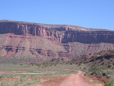
I started my hike about 1 mile down the River Road, past a couple of small buildings, well before the road exits the Paradox Valley and enters a deep canyon of Wingate Sandstone cliffs sitting on the shale of the Chinle layer. The Paradox Trail is named for the odd situation where the Dolores River flows perpendicular across the valley, entering and exiting through steep canyons.

The Dolores River flow is controlled at the McPhee Dam near the town of Dolores and the flow was low during my hike even though mid May is a peak runoff period. The stream appeared to be carrying a lot of sediment.

The walking is easy along the gravel road and only three cars came by during the time I was hiking. I kept an eye out for signs of Indian ruins and petroglyphs but didn’t see any. There wasn’t much riparian habitat along the Dolores River here. The canyon sides were covered with sagebrush and Utah Junipers.
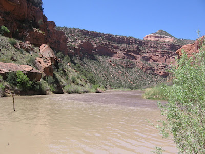
It took me 2:15 hours to cover the 6.3 miles to the confluence of the Dolores and San Miguel Rivers. The San Miguel is one of the few western rivers to not have a dam on it, and its flow dominated the joined flows.

The Dolores and San Miguel start in the same area. The water flowing south from Lizard head Pass near Telluride flows about 50 miles south in the Dolores River before turning back to the north. Water flowing north from the same pass enters the San Miguel system and flows west. After long journeys apart, the waters rejoin in this remote canyon.

There was a small party of rafters getting ready to get underway here at the confluence. They were setting out on a 100 mile trip to Moab, following the Dolores/San Miguel to the Colorado.
I retraced the 6.3 miles back to my car, completing about 12.6 miles in 5:00 hours. It was about an 85 F. degree day in mid May and there isn’t much shade along this route. After hiking, I drove the route that I had hiked and then followed the River Road upstream toward Uravan.

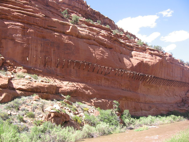
Along this section there are remains of the Hanging Flume. This water structure was built in 1888-1891 and moved 23 million gallons per day 17 miles to the Bancroft Placer site to wash gold from the gravel. In that era, the technology to pump water at the volume and pressure needed wasn’t available.

Uravan, at the end of the road is the site of a Uranium and Vanadium processing plant that operated from 1936 to 1984. There is an ongoing cleanup project to restore the canyon area to its pre-milling condition. Uravan and the Hanging Flume are among the points of interest in the middle of the Unaweep-Tabequache Scenic and Historic Byway on highways 145 and 141.

In the Paradox Valley area, there is also a good hike starting at the Bedrock boat launch site upstream into the Dolores River Canyon Wilderness Study Area.